Explore to Indonesia

  • Home
  • Features
  • _POST FORMAT
  • _Error Page
  • Trending
  • contact
South Sulawesi has many tourist destinations that are not inferior to other tourist destinations throughout Indonesia. In fact, if viewed carefully, South Sulawesi is worth mentioning as 'Bali baru'.
This is the reason why South Sulawesi deserves to be called 'Bali baru'

South Sulawesi has Losari Beach that is not less crowded at Kuta beach Bali

new bali
Photos from here
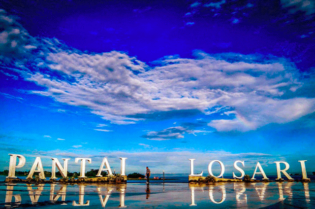
Losari Beach was once dubbed the beach with the longest table in the world. This is because there are many stalls along the beach. These tent stalls indicate that once, Losari beach is very famous. No less prestige with Kuta beach Bali.

South Sulawesi has Tanjung Bira that is not less cool Nusa Penida Bali for snorkeling business

new bali
Photos from here
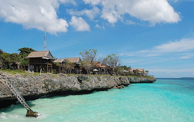
Tanjung Bira tourism is not only known by domestic tourists only, but to foreign countries. Do not believe? try deh to Tanjung Bira and see the beauty of the underwater that is not inferior to Nusa Penida. This is a plus for South Sulawesi to become a 'new Bali'.

In South Sulawesi, there is Trans Studio Makasar not less crowded with the playground in Bali
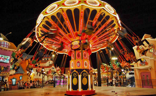
new bali
Photos from here
Standing on an area of ​​2.7 hectares, Trans Studio Makasar is crowded by visitors who are not inferior to Green Park Kuta, or other playgrounds in Bali.

South Sulawesi has a market in the famous Somba Opu Makasar Street

new bali
Photos from here
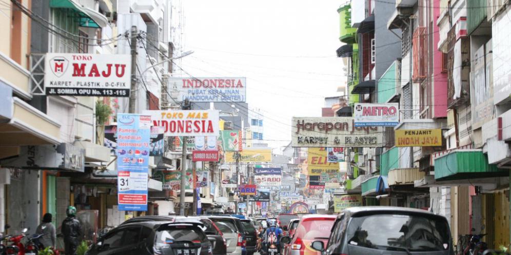
From the washing oil typical of South Sulawesi, Songkok To Bone, Sengkang Sutera, sarong mandar, Toraja coffee, until the typical snack of South Sulawesi are all there.

Rammang-Rammang : The Halong Bay of Sulawesi


South Sulawesi has a unique Bantimurung National Park and full of butterfly species

new bali
Photos from here
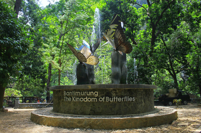
Seeing the wild animal scene is already commonplace, but when in Bantimurung National Park you will find a butterfly insect that roamed here and there. Funny?
In addition to the various types of butterflies, in Bantimurung National Park has beautiful scenery such as, hills, caves, waterfalls, and many others.

Sulawesi also has an Ammatoa custom area which is no less cool than Balinese custom

new bali
Photos from here
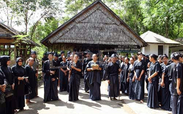
Located 56 km from Balakumba, Tana Toa village has many uniqueness like Bali island.Despite having a different culture from Bali, Ammatoa custom also has a cool existence.
You should occasionally visit the village of Tana Toa.

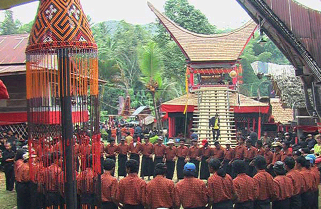
South Sulawesi has a really cool Ke'te Ke'te! You will see the custom house still in use today

new bali
Photos from here
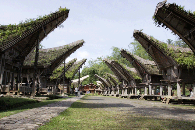
Ke'te Kesu means the center of activity. The center of activities in South Sulawesi includes villages, handicraft centers, to customary graves. This is a form of Tana Toraja known for its traditional customs and life of its people throughout the archipelago.

South Sulawesi is famous for the famous Pinisi shipbuilding craft all over the world

new bali
Photos from here
Pinisi wooden ships have been used in Indonesia for centuries, and are thought to have existed before the 1500s. This pinisi is a typical Indonesian sailing ship from the Bugis and Tribe of Makassar, precisely from the village Bira Bonto Bahari District Bulukumba District.
In its history, Pinisi was first made by the Crown Prince of Luwu to sail to China to marry Chinese princesses. Hem .. So sweet, yes!

South Sulawesi also has processed Nasu Palekko duck that tastes spicy crazy! No less equally duck betutunya Bali

new bali
Photos from here
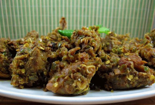
duck nasu palekko 'is typically duck-based duck-basted cuisine with spicy flavor, this dish is very popular for the people of South Sulawesi

Although different ethnic and religious, South Sulawesi always live side by side

new bali
Photos from here
South Sulawesi has several tribes, namely; Bugis, Makassar, Mandar, Toraja, Duri, Pattinjo, Bone, Maroangin, Endekan, Pattae, Kajang / Konjo and various religions but always live side by side. Like Bali, South Sulawesi is feasible to be the destination of your next destination.

***

There are still many things that show that South Sulawesi deserves to be called 'Bali Baru'.What do you think? Agreed, right?


  • 0 Comments

Fort Rotterdam (Benteng Ujung Pandang as it is now called) is an Old Dutch colonial fort in Makassar, overlooking the harbor. It is one of the top attractions in Makassar.
The current fort was built by the Dutch around the year 1667 but the first defensive structures consisting of a simple dirt wall where built here a century before in 1545 by Raja Tunipalangga. The Dutch Admiral Cornelis Speelman concurred the fort in 1667 and renamed it after his birthplace, Rotterdam. Soon the fort was rebuilt with 6 meter high and 2 meters thick walls. In the inside arose Dutch houses and a church. The fort became the center of Dutch colonial power on the island of Sulawesi.
Fort Rotterdam kept it function till 1937 after which it got other functions. In the 1970s the fort was restored and renamed to Fort (Benteng) Ujung Pandang. It is one of the best preserved Dutch buildings in Indonesia.
Fort Rotterdam consists of five towers, four on each corner and one at the main entrance. Inside are thirteen buildings, eleven made by the Dutch and two were built by the Japanese. The oldest building was built in 1686 and is called the Speelman's house, after the admiral who concurred the fort although he never actually lived in the house. The house was used by Dutch governors till mid-19th century. Currently a museum is housed here. Other structures were used as sleeping quarters for officers, prison or warehouses. One of the leaders of the Java war (1825-1830), the Indonesian National Hero Prince Diponegoro, was imprisoned here for 26 years till his death in 1855.
Fort Rotterdam is open every day from 08:00 till 18:00 hour. Entrance is free although a donation is requested, Rp. 10,000 should suffice. The museum is only open Tuesday to Sunday in the morning from 8:00 till 12:30 hour, entrance is about Rp 7500.
Located right in the heart of Makassar, it is not difficult to get to Fort Rotterdam. You can take the local public transportation or pete-pete, or taxi to get to the fort. If you are happen to be in Losari Beach, you can simply stroll down the boulevard and enjoy the scenery before you reach Fort Rotterdam.
  • 0 Comments

Bantimurung National Park is a 480 km2 large nature reserve just 45 km north of Makassar / Ujung Pandang. The name Bantimurang is a combination of the words 'membanting kemurungan' which means 'getting rid of sadness'. The park is famous for its many butterflies. When Sir Alfred Wallace visited this area in 1856 he termed it the 'Kingdom of butterflies'. A name still used till today.
Unfortunately the number of species and amount of butterflies has dropped significantly in the last decades. In the first count there were 270 species, a count in 1997 stopped at 147 species. The last count in 2010 could only found 90 species. Also, besides a decline in species, the total amount of butterflies has dropped significantly: before there were so many butterflies they would gather in groups and drift by in a cloud.
Increased human activity in the area is seen as the cause of this decline. In a response the government has started a butterflies breeding program. But in spite of the decline you can still enjoy the thousands of multi-colored butterflies here especially in or near one of the caves.
Besides the butterflies this National Park is famous for the 15 meter high waterfall. This is the place where most visitors go to. Behind the waterfall are a few caves which you can explore. The waterfall and caves are set in a lush tropical forest with limestone cliffs.
Bantimurang National Park is especially popular in the weekends when local visitors from Makassar head out to the waterfall and adjacent picnic area. Park entrance is Rp 5,000 per adult. Accommodation to spend the night is available inside the park perimeter for as low as Rp 50,000.
Located only 20 KM from Hasanuddin Airport, the national park can be reached from the airport by local public transportation called pete-pete for about 30 minutes. If you travel from Makassar, you can catch a public bus or DAMRI, from the Makassar Mall in the direction of Maros for about one hour. From Maros, take the same pete-pete that also goes to the airport.
  • 0 Comments

Twenty-six red-and-white hand prints are plastered across the roof of the Leang Petta Kere cave in the Bantimurung subdistrict of Maros, South Sulawesi. At its center is a painting of a red boar, spanning half a meter in length. Apparently the cave’s previous inhabitants expected a pretty big meal to keep everyone fed.
“This is a relic of the middle Stone Age people, hunter gatherers who lived here around 5,000 BCE,” says Lahab, an official from the Makassar Center for Cultural and Heritage Preservation, at the Leang-Leang Prehistoric Park.
In the native dialect, “leang” means “cave,” “petta” means “nobility,” and “kere” is “sacred”: so Noble, Sacred Cave.
Leang Petta Kere is one of about a hundred caves that have been identified by the Makassar Center for Cultural and Heritage Preservation as once being home to hunter gatherers.
Visiting this ancient site, 45 meters above sea level and a 30-meter climb up a ladder, feels surreal, almost like looking through a window into the life of prehistoric men.
At the entrance to the cave forms a sort of antechamber, and it is here where the palm prints are found. “The palm was believed to repel, so that evil forces and wild animals wouldn’t enter,” Lahab says.

The prints themselves are a dirty white, like the rest of the cave walls, and are outlined by a red halo. It’s believed that the people who created the prints put their hands up against the wall and spit chewed-up foliage to create the outlines.
Some of the prints are red, supposedly created by dipping the hand in water tinted with the chewed-up leaves and stamping them on the wall.
“Researchers still don’t know what kind of leaves were used. In another cave, not in this region, black handprints have been found. Those are thought to have come from a later period than these ones,” Lahab says.
Some handprints have only four fingers and no thumb — “a sign that the person was mourning. They cut off one finger every time an elder of the group died,” Lahab says.


The cave holds many surprises. At the end of a narrow entrance lies a fairly spacious living space. A niche about 1.2 meters in diameter is believed to have been the center of ceremonies for the cave’s inhabitants.
There are dozens of other smaller niches, all connected to one another and forming a network of resting places. Inside, the cave protected the prehistoric humans from the scorching sun. The temperature inside remains a pleasant 27 degrees Celsius throughout the day.
“This cave was occupied by several different groups. One group consisted of 30 to 35 people,” Lahab says.
Archaeologist have found artifacts such as flint blades and stone arrowheads. As hunter gatherers, the cave people had a mountain of kitchen waste, a dump for the bones and shells of the animals they are. These fossilized remains are scattered at the mouth of a second cave, called Leang Pettae.
The latter was the first cave to be studied from among the hundred or so in the Maros Karst-Pangkep region. Here, five handprints were found along with a smaller image of a boar impaled with an spear. One of the five palms is though to belong to a woman, Lahab says.
The exploration of the cave began in 1950 by Dutch archaeologists, who stumbled upon the caves that locals had been using to house their livestock.
Finding the caves today is easy. The region boasts the world’s longest limestone mountain range, or karst landscape, and has caves scattered everywhere.
The local residents have for years used these caves.
“When I was little the caves were a place to keep our cattle. Leang-Leang Prehistoric Park was once a rice field that also belonged to the locals. I’ve worked here as a caretaker since 1985, after it was designated a cultural heritage park,” says the 51-year-old Lahab.
A resident of Tompok Balang village in Bantimurung subdistrict, Lahab says the tradition of making handprints is still carried out by local residents, notably when the first beam of a new house is erected.
A priest dips his hand in rice flour and stamps his print on the beam, with the owner of the house following suit.
“This tradition is called ambedak, or applying face powder. The hand print fades away quickly because they only use rice flour,” Lahab says.
Large chunks of limestone and andesite, a volcanic rock, are scattered irregularly around Leang-Leang Prehistoric Park. But a closer look reveals that they are laid out almost like the rocks of Stonehenge in England.
“Many foreign tourist from Britain and Australia are interested in the andesite stones. Since I was little, the stones have been laid out like this; no one dared move them,” Lahab says.
The Leang-Leang cave is easily reachable from Makassar, the South Sulawesi capital about 30 kilometers to the south.
Visiting Leang-Leang offers a new sensation for those bored of the daily traffic jams of Makassar’s busy streets. The road out of town is lined with beautiful irrigation canals and rows of tamarind trees, which bear fruit in April and June.
After passing through the main gate to Leang-Leang, the scenery becomes very different. The tamarind groves give way to rice fields and limestone foothills. The water seeping through the limestone filters down to the rice paddies.
Entry into the park costs Rp 10,000 (84 cents), and there you can find Lahab and six other guides all ready to show you around and regale you with tales of what it must have been like 7,000 years ago.
And unlike the cave inhabitants who needed a whole hog, the guides will gladly settle for a bowl of meatball soup as a tip at the end of the tour.
  • 0 Comments

Takapala Waterfall has 109 meters high with huge volume of water that pour out daily, and becomes bigger during rainy season. The outpouring of water that hit the big chunks of rocks in the bottom causing a roar and a splash of water that form a thin haze as far as 20 m.
Not far from Takapala there are also other waterfall names Ketemu Jodoh Waterfall; the name of Ketemu Jodoh means meeting a soulmate. The location of the waterfall is only separated by a road that leading to the village of Majannang, District Parigi. According to the people around the waterfall this waterfall believed to provide convenience for everyone who comes to bathe while intending to get a mate for marriage.
Takapala waterfall is located in the village of Bulutana, District Tinggimoncong, Gowa regency, South Sulawesi Province, it lies around 70 km from Makassar and it takes about 1 hour drive or 6 km from the town of Malino, the capital district of Tinggimoncong. The road to the waterfall is relatively good with a little winding up and down hills, just a few points encountered potholes. Along the way we will pampered by the pretty sight with one of the road side that indicating a bottomless.
  • 0 Comments

In the language of Makassar, Rammang-Rammang means a collection of "clouds" or "fog" that ultimately inspire the naming of tourist attractions in Maros, Pangkep Makassar because according to local people's story, the area around Rammang-Rammang is often shrouded in clouds or fog during morning or when it rains. Well that then makes the location of Rammang-Rammang is becoming very famous is the cluster of karst mountains (limestone mountains) that surround this region, both on the land and the river which makes the surrounding scenery is very beautiful and exotic. Wikipedia sources even mention that this karst Rammang-Rammang mountain region is the 3rd largest in the world after Tsingy in Madagascar and Shilin in China, wew ... Indonesia KEREN!

rammang rammang maros 0
Cave in Pute River, Rammang-Rammang Maros Makassar

There are several ways to enjoy the beauty of cluster of karst mountains in Rammang-Rammang this, the first by way down the Pute River in this area, then by way of roaming a village that is in the middle of this area after going through the flow of Pute River, which is Kampung Berua and the last one is to directly visit the spot of rocks and karst karst from the land side, on the edge of the fields and the surrounding hills. Well in this part 1 article I will share a story about the beauty of Rammang-Rammang along the Pute River that will take us to the center of Kampung Berua for the next trekking around this cluster of karst mountains.

rammang rammang maros 1
Unique Rocks on the River Pute, Rammang-Rammang Maros Makassar

To down the Pute River there are 2 (two) docks that can be our starting point, namely dock 1 which is located in the axle road of Cement Plant Bosowa and dock 2 which is located not too far from dock 1. In general it is actually quite difficult also to be able to to the location of this pier, because almost no guidance signs leading to this place. So, input ya for local tourism managers to be able to complete the guidance signs not only when approaching the dermaganya but also since the journey from around the city of Maros that leads to the Rammang-Rammang tourist area is very minimal instructions. Thanks to my bro Kak Roy who had survey a few days earlier, so our group can be successful to get to the location on time without getting lost. Try it if the first time and have to find the location first, waaaa can not chase my aircraft schedule back to Jakarta ... wkwkwk.

rammang rammang maros 6
Rammang-Rammang, Maros Makassar

Well this time we took the starting point from Pier 1 by hiring a boat with a capacity of 7 people. Oiya rental rates vary hamper ya gaes, depending on the size of the ship and the number of people. The tariff is already officially plastered on the dock, so make sure we pay according to the official rate. For ships with a capacity of 1 to 4 people, the tariff is Rp 200 thousand pp, capacity 5 to 7 people the rate is Rp 250 thousand pp and the capacity of 8 up to 10 people to the tariff of Rp 300 thousand pp. The location of Pier-1 which is located in the axis road of Cement Plant Bosowa is located approximately 40 km from the city of Makassar precisely on the border town of Maros and Pangkep, which can be reached within about 1 to 1.5 hours drive from Makassar.

rammang rammang maros 5
Chalk Hills along the Pute River, Rammang-Rammang Maros Makassar

The interesting thing about starting our journey is the limestone rocks in the middle of the river close to the location of the pier. Hmmm seemed to be in Belitung aja nih, just the difference if in Belitung most of the stones on the beach, if here the rocks in the river. But it is only in this spot wrote a lot of river stones, while the next journey no longer visible rocks in the middle of the river, although there are also some stones on the riverbank, but only a little, the rest is a stretch of river with greenish water color that sometimes widen the river or narrowed in certain spots. Well this section taste-it feels similar to Mangrove Forest tour in Nusa Dua Island Bali, only difference if in Bali the river is more narrow and almost closed with trees Mangroves, as if we walk in the river roofed Mangrove trees. While in the Pute River is more open nature, but also surrounded by shady trees, but the scenery of the hills and karst mountains around it is very clear, even it will feel very sunburn if your journey is proper in the day hole ... hehe. So do not forget to bring a hat and sun block, bro sis, guaranteed to burn deh kalo over time!

rammang rammang maros 4
Sights along the Pout Rammang-Rammang River, Maros Makassar

Oiya, at some point in this river we too will pass the caves decorated with unique carvings on the walls ... hmm .. beautiful hell, like carved aja nih, but natural loh. In addition, Pute River is also surrounded by karst mountains that clearly visible because of its contiguous location. Some historic caves we can see from a distance on the mountains. If interested, can be discussed with the driver of the ship to stop by climbing trekking up to the cave on the hill, so prepare the mountain sandals and stamina ok ya gaes, guaranteed tired of course. Because we all pengennya tourist casual-just wrote besides me also just use the sandals flops, how the story want trekking manjat-manjat ya? ok mang ship, go on the way, trekking to the cave next time aja deh, let me have a reason to come back here next time, hahaha!

rammang rammang maros 3
Pute River, Rammang-Rammang Maros Makassar

After about 45 minutes of our journey down this Pute River and having met some lizards, ducks, geese, birds and other animals that roam along this river bank, we arrived at the final stop to go to Kampung Berua Rammang- Rammang which means, trekking trip in the mainland along the fields, ponds and hills, we will start from now.

rammang rammang maros 2
Pute River, Rammang-Rammang Maros Makassar - SELFIE time
  • 0 Comments
Postingan Lama Beranda

Where we are now

o

About me

a


Janice

"The most important thing is to enjoy your life — to be happy — it’s all that matters.”


Follow Us

  • bloglovin
  • pinterest
  • instagram
  • facebook
  • Instagram

Banner spot

recent posts

Labels

Bali East Java Jogjakarta Komodo Island Makassar Manado Maros Northern Sulawesi South East Sulawesi South Sulawesi Sulawesi Tana Toraja Traditional House

instagram

Template Created By : ThemeXpose . All Rights Reserved.

Back to top